Archaeologists from the Anthropology Department at Brown University and at the University of Massachusetts Boston came to the Akin site to assist in preparations for our dig. We used a digital surveying device - a Total Station - to plot a grid system over the site. This grid will allow us to track the X and Y coordinates of our excavation units. Fortunately, there is a USGS "benchmark" just across the street from the Akin House. The benchmark is a small brass disc permanently fixed to a rock. It has a known latitude, longitude, and elevation. By tying our grid to the USGS benchmark, we know where we are working in real space.

We were also fortunate to have an expert in geophysical prospection from Brown University visit the site. He used an electromagnetic induction unit to measure the magnetic and conductive properties of underground deposits. This and other types of geophysical prospection help archaeologists identify potential cultural features and better plan our excavations. He is working to process the data. Raw results from the field suggest some linear features in the rear yard (stone paths?) and a semi-circular feature in the side yard (purpose unknown!).
 Archaeologists from the Anthropology Department at Brown University and at the University of Massachusetts Boston came to the Akin site to assist in preparations for our dig. We used a digital surveying device - a Total Station - to plot a grid system over the site. This grid will allow us to track the X and Y coordinates of our excavation units. Fortunately, there is a USGS "benchmark" just across the street from the Akin House. The benchmark is a small brass disc permanently fixed to a rock. It has a known latitude, longitude, and elevation. By tying our grid to the USGS benchmark, we know where we are working in real space.
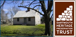
 We were also fortunate to have an expert in geophysical prospection from Brown University visit the site. He used an electromagnetic induction unit to measure the magnetic and conductive properties of underground deposits. This and other types of geophysical prospection help archaeologists identify potential cultural features and better plan our excavations. He is working to process the data. Raw results from the field suggest some linear features in the rear yard (stone paths?) and a semi-circular feature in the side yard (purpose unknown!).